Hiking Trails
Here are links to hikes in the area that have been organized by "Toxaway Tony". Tony organizes hikes every other Friday from Amore Cafe on Rout 64 just west of the Lake Toxaway Waterfall at 8:45 AM http://[email protected] If you want to participate in a hike, you can go to his website to check on the hike that Friday or you can e-mail him. I have organized links to many of his previous hikes, which give you pictures and directions for those hikes. If you want to do those hikes on your own there are printable versions of the hike directions, so you can print out the directions ahead of time. If I have been on the hike, I have given you my comments. For additional hikes to waterfalls not listed here, go to http://http:visitwaterfalls.com
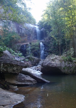
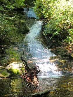
Rough Run Falls and High Falls Trail
45 minute drive
2 hr hike roundtrip
Easy (2)
This is an easy one hour hike to the falls. There is a second fall on the right about half way. It is located about 8 miles north of Cashiers. I really enjoyed it and thought it would be a great place to take the kids for a dip in the pond at the bottom of the fall. For directions and more pictures go to
http://toxawaytony.com/TG_roughrunfalls.html
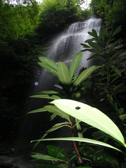
Rhapsodie Falls
5 minute drive
2.5 hour hike
medium to difficult (4-5)
The falls are breath taking. There is so much mist in the air, it is difficult to take a photo without getting water spots on your lens. There are two water falls on this hike. The first one is a stair step fall that is very pretty. But do continue up a very steep and often a bit muddy trail to this awesome fall. It is a bit strenuous on some very steep parts but it is definitely worth the hike. Drive west on Silversteen and make a right onto 281. Then follow Tony's directions in the link.
http://www.toxawaytony.com/TG_rhapsodie.html
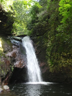
Courthouse Falls
30 minute drive
medium difficulty (40
1.5 hour hike round trip
The drive from Rout 215 to the trail head is on a dirt road. Occasionally you will see some crazy local climb behind the fall and then jump into the pond. The water is ice cold .
Take Macedonian Church Road from the house and turn left onto 215. Follow Tony's Directions from there.
http://www.toxawaytony.com/TG_courthouse.html
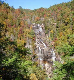
White Water Falls
40 minute drive
Easy (1-2)
30 minutes
2nd hike
Medium (4)
2.5 hours
This beautifull waterfall view is wheel chair accessible. The path to it is asphalt and only has a slight incline. Drive from the cabin west on Silversteen to Route 281 and head south to Route 64. Take Route 64 to 281S. From here follow Tony's directions. Here are some hikes that Tony has led
http://toxawaytony.com/TG_Whitewater.html
http://toxawaytony.com/TG_Lowerwhitewater.html

Gorges State Park
Driving time: 25 minutes
Difficulty 2 - 4
Several hike options
Rainbow Falls - 2.5 hrs round trip
Drive west on Silversteen to 281 and head south to Route 64. Head west to Route 281 S. and follow Tony's directions. This is a beautiful area to hike with several hiking options and good trail Maps at the Trail Heads.
http://ToxawayTony.com/TG_rainbow.htm
TOXAWAY RIVER TRAIL to Fisher Falls
Driving time: 20 minutes
Difficulty: 2
Hiking time: 1 hour round trip
Drive west on Sylversteen and then south on Route 281. Just before you get to the Firestation take a right on Cold mountain Road. Head north until you see a sign on your left for the Greystone Inn. This is Fairview Drive. Drive for a mile and make a turn on Cardinal Drive until you see the sign for the trail head.
http://toxawaytony.com/TG_toxawayriverph1.html
PANTHERTOWN VALLEY HIKES
Driving Time: 30 minutes
Take Silversteen west and then head south on Route 281. Just before you get to the Firestation, make a right onto Cold Mountain Road and follow it to its end, where you'll see signs to the trail head. There is a large Map with trails marked. I have taken the Green Land Creek hike and it was pretty easy , if not a bit muddy in places. The School House falls Hike is very easy.
Greenland Creek, Carlton Falls
Difficulty: 2
Hiking time: 1.5 hrs round trip
Holly Falls
Difficulty: 4
Hiking time: 3 hrs round trip
http://toxawaytony.com/TG_greenlandcreek.html
Granny Burrel Falls
Difficulty: 4
Hiking time: 3.5 hrs round trip
http://toxawaytony.com/TG_granny.html
Blackrock Overlook Trail
Difficulty: 3
Hiking time: 1.5 hrs round trip
http://toxawaytony.com/TG_blackrock.html
Others:
http://www.toxawaytony.com/TG_ridingfordfalls.html
http://www.toxawaytony.com/TG_PF_littlegreen.html
http://www.toxawaytony.com/TG_warden.html
http://toxawaytony.com/TG_graveyardfields.html
Whiteside Mountain
Take Silversteen west to 281. Head south to Rout 64 and drive west through Cashiers until you come to the Whiteside Mountain sign. Turn left and follow the signs to the parking lot. These two hikes are amazing with views across valleys and Mountains to the south, east and north.
Driving Time: 1 hr
Difficulty 2 -5
Hiking time 1-3 hrs
http://www.toxawaytony.com/TG_whiteside.html
Hikes from Route 276
http://www.toxawaytony.com/TG_johnrock.html
http://www.toxawaytony.com/TG_lookingglass.html
Hikes from the Blue Ridge Parkway
Sam Knob Overlook (MP 420)
Driving time: 45 minutes
Difficulty: 2
Hiking time: 1.5 hrs
For a 360 degree view from a 6000 foot summit, a view considered one of the best in NC, try this fairly easy hike.
Take Silversteen Road to the east and head north on Macedonia Church Road. Turn north onto Route 215 and take it to the Blue Ridge Parkway. From there follow Tony's Directions.
http://toxawaytony.com/TG_samknob.html
